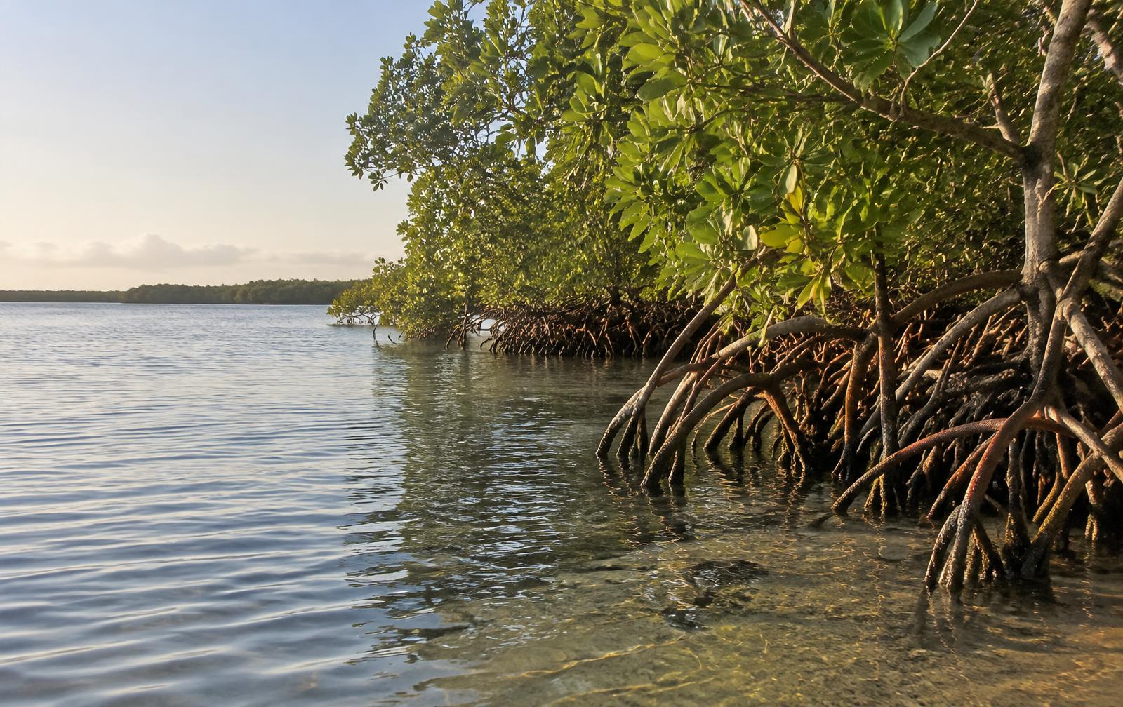
Illustrative AI-generated habitat image, not a photograph of a specific park or our property. Red mangroves are recognizable by their arching prop roots.
Quick answers
- Why are mangroves important to the Indian River Lagoon?
- Their roots shelter fish and other wildlife, stabilize shoreline sediment and help reduce erosion. Mangrove vegetation and soils also store carbon. They are one part of a connected estuary that also depends on healthy seagrass and water quality.
- Which mangroves grow in Florida?
- Florida has three native mangrove species: red, black and white. Red mangroves have arching prop roots; black mangroves have upright breathing roots; white mangroves usually lack those conspicuous root structures.
- Do I need a kayak to enjoy mangrove habitat?
- No. Mainland trails and the observation tower at Pelican Island National Wildlife Refuge offer a land-based way to appreciate the lagoon landscape. If you paddle, choose a route suited to your ability and the day's weather.
At first glance, it looks like a mess: roots leaning into the water, leaves layered over leaves, a shoreline with no neat edge. Then a small fish flashes between the roots. A crab disappears around a trunk. The water moves, but the sediment beneath it barely seems to stir.
That tangled edge is not wasted space. It is a working forest.
Around the Indian River Lagoon, mangroves are part of the scenery people photograph without always noticing what they do. They help hold shorelines together, shelter young marine life and store carbon in places you cannot see from a boat. Once you understand them, a quiet paddle becomes something more interesting than a search for the next dolphin.
The Project SeaSafe article you may have seen tells the story of Cory Redwine's New Swell mangrove restoration initiative on Florida's Space Coast. That local story inspired this guide. Here, we look beyond the project to the science — and to what you can observe near Grant-Valkaria and Sebastian.
1. The nursery hiding under the leaves
Imagine a young fish crossing open water. There is nowhere to hide. Now imagine that same fish slipping into a maze of roots: narrow gaps, shaded water and surfaces crowded with small organisms.
Structure changes the odds. NOAA describes mangrove roots as habitat that supplies food and shelter for fish and other organisms. Florida's Department of Environmental Protection also recognizes their nursery role for many game and sport fisheries.
It is not simply that fish live beside trees. The roots add physical complexity to the shoreline, while fallen leaves enter a food web of decomposers and small consumers. The forest supports life both above and below the surface.
That helps explain why anglers pay attention to vegetated edges. It does not mean every stretch holds the same fish, or that a mangrove shoreline guarantees a catch. Conditions, seasons and habitat quality still matter. For the practical side, use our local fishing guide, and bring your own rods and tackle.
Try this: from a respectful distance, look into the shaded water between the roots rather than scanning only the open lagoon. Small movements can tell a bigger story than a dramatic wildlife sighting.
2. A living shoreline, not a hurricane force field
Mangroves do something a concrete-looking shoreline cannot show you: their roots slow moving water and help suspended sediment settle. Over time, this supports shoreline stability and can reduce erosion from waves and currents.
NOAA also identifies protection against storm-related erosion among their benefits. But a crucial distinction belongs in every conversation about mangroves: they help buffer a coast; they do not make it storm-proof.
The protection depends on the forest and the conditions. A narrow fringe is not the same as a broad, healthy wetland. A mangrove-lined bay is not permission to ignore wind, lightning or flood warnings.
For visitors, the practical lesson is simpler: treat the roots as living infrastructure. Do not run a hull through them, tie a boat to them or break branches to make a passage. Avoid adding boat wake to a vulnerable shoreline.
3. The biggest carbon story is partly underground
You can see a mangrove's branches. You cannot see most of the story beneath them.
Mangroves are one of the coastal habitats associated with blue carbon — carbon captured and stored by coastal and marine ecosystems. NOAA Fisheries explains that these habitats store carbon in vegetation and soils, with much of the stored coastal carbon held below ground.
This is why protecting a wetland involves more than counting trees. Its soil matters too. Disturbing or losing the habitat can undermine that carbon storage.
You may encounter headlines claiming mangroves store a fixed number of times more carbon than another forest. Those comparisons depend on what is being measured, the location and whether soil is included. There is no defensible carbon total for a particular shoreline here without measurements. The useful takeaway is not a flashy multiplier: a healthy mangrove ecosystem is a valuable carbon store, including the mud under your paddle.
4. Three Florida mangroves you can learn to recognize
Florida has three native mangrove species. You do not need to memorize Latin names to start noticing the differences, but the names help keep your observations precise.
| Mangrove | Scientific name | What to look for |
|---|---|---|
| Red mangrove | Rhizophora mangle | Arching prop roots reaching from trunks and branches toward the water |
| Black mangrove | Avicennia germinans | Short, upright breathing roots rising from the soil around the tree |
| White mangrove | Laguncularia racemosa | Usually no conspicuous prop or breathing roots; glands near the base of the leaf blade can help identification |
These are clues, not a foolproof identification key. Water level can hide roots, and plants do not always look like textbook diagrams. Observe without pulling leaves or trampling the sediment.
Red mangroves offer another small wonder: their seeds begin developing while attached to the parent tree. The elongated young structures, called propagules, can eventually detach and disperse in water. If you spot one, photograph it in place — do not collect or plant it in a park.
A simple family challenge: find an arching root, a reflection and a sign of animal life. You can enjoy the forest without touching a single thing.
5. Mangroves and seagrass are neighbors, not the same habitat
The Indian River Lagoon is an estuary, a system where freshwater and saltwater meet. Its name can mislead visitors into imagining an ordinary flowing river. Its habitats are connected, but they are not interchangeable.
Mangroves are woody shoreline trees. Seagrasses are submerged flowering plants. Their meadows provide habitat of their own and are important food for manatees.
A mangrove shoreline is therefore not a replacement for a healthy seagrass bed. Nor can trees alone solve nutrient pollution, harmful algal blooms or all the lagoon's water-quality problems.
That distinction also improves wildlife watching. A manatee moving near a mangrove edge is not evidence that it is eating the roots. Give it space and let it choose its path. Our manatee and wildlife guide connects you with local viewing locations.
6. Where to start near Grant-Valkaria and Sebastian
You do not need an expedition or a guaranteed mangrove tunnel to appreciate this landscape. Choose the experience that matches your ability and the day's conditions.
A lagoon paddle from Grant-Valkaria
Guests at Sunrise on the River have a private dock and kayaks included with their stay. That makes time on the lagoon part of the visit rather than another rental appointment. See our dock and on-the-water amenities and the kayaking and paddleboarding guide for local launch options.
Treat this as an opportunity to observe lagoon habitat, not a promise of a particular mangrove route from the house. Plan your return before setting out, check the forecast and ask a local outfitter about any unfamiliar route.
The St. Sebastian River
Indian River County lists Sebastian Canoe Launch, at 9800 Canoe Launch Cove, as a kayak and canoe access on the South Prong of the St. Sebastian River. Its description connects the waterway with Donald MacDonald Park, Dale Wimbrow Park and the lagoon.
That is a useful starting point for route research, not a suggestion to paddle the entire connection in one outing. Check the county's launch information, current access and conditions, and choose a turnaround appropriate to your experience. Expect a changing river landscape rather than mangroves along every bank.
A land-based lagoon view at Pelican Island
Prefer to keep your feet dry? The mainland Centennial Trail and observation tower at Pelican Island National Wildlife Refuge give you a way to appreciate the lagoon and its island habitat from land.
Check official refuge visitor information before traveling. The bird-nesting island itself is not a landing destination; respect posted closures on the water. Our Pelican Island visitor guide helps connect the visit with the wider area.
7. How to visit without becoming the disturbance
The best mangrove encounter is one in which the animals barely notice you.
- · Watch; do not pursue. Never feed, touch, chase or surround a manatee or other wildlife. FWC advises paddlers to back away if a manatee changes its behavior in response to them.
- · Keep roots and branches intact. Do not push through vegetation, hang equipment from trees or step into a root bed for a photo.
- · Give nesting birds room. Respect closure signs and avoid paddling toward a rookery simply for a closer shot.
- · Wear a life jacket and carry safety equipment. Bring water, sun protection, a whistle and a way to call for help; tell someone your plan.
- · Read the actual weather. Early light is beautiful, but an early departure does not guarantee calm water. Wind, lightning and boat traffic can change the plan.
- · Stay away from the inlet cut. Sebastian Inlet's strong tidal currents and boat traffic are not suitable for a casual kayak outing. A quiet-looking photo or camera feed is not a safety clearance.
- · Leave no trace. Take litter home. Leave shells, seedlings and natural materials where they belong, and use authorized access points.
8. What the New Swell story gets us thinking about
Project SeaSafe's article describes Cory Redwine nurturing red mangroves at local marinas and restaurants for a restoration effort at Marker 24 Marina on the Banana River. It reports a goal of 3,000 mangroves.
That number is a goal described by the source, not a planting total we have independently confirmed, and the article is not a current volunteer schedule. The Banana River project is also a separate Space Coast location, not a restoration activity at our dock in Grant-Valkaria.
What makes the story interesting is the connection between an everyday waterfront place and habitat stewardship. A marina or restaurant can become a place where people learn that the trees along the water are doing essential work.
If you want to help, check the project's current information before making plans. Support authorized restoration rather than planting wherever a shoreline appears empty: site suitability, permissions and long-term care matter.
And do not trim a mangrove for a better view. Florida's Mangrove Trimming and Preservation Act regulates trimming and alteration. Exemptions and permit requirements depend on the circumstances. Consult Florida DEP's mangrove program and the relevant local authority before any work.
A different way to spend a morning on the lagoon
You do not have to see a dolphin for a morning here to feel worthwhile. Watch the light move across the roots. Notice where ripples soften against the shore. Look for the small life that makes the larger life possible.
Sunrise on the River is a 3-bedroom, 2-bath waterfront home in Grant-Valkaria, sleeping up to eight guests with 1 King and 3 Queen beds. A private dock and included kayaks put lagoon time within reach, while nearby trails and refuges offer another way to explore.
See the house, browse the photo gallery or check available dates to plan your stay. Come for the water view. Leave knowing a little more about what keeps that view alive.
Sources and further reading
Research reviewed October 24, 2026. This is an original local guide; Project SeaSafe supplied the inspiration, while the ecological explanations draw on the sources below. Access, weather and conservation-program details can change.
- · Project SeaSafe: Cory Redwine's New Swell mangrove project — the local restoration story and its stated planting goal.
- · NOAA Ocean Service: What is a mangrove forest? — roots, habitat and shoreline protection.
- · NOAA Fisheries: Protecting coastal blue carbon — carbon storage in coastal vegetation and soils.
- · Florida DEP: What is a mangrove? — Florida's species and identification clues.
- · Florida DEP: Mangrove program — ecological importance and trimming regulation.
- · FWC: Manatee guidance for paddlers — responsible observation on the water.
- · FWC: Manatee guidance for boaters — seagrass and manatee habitat.
- · Indian River County: Sebastian Canoe Launch — local launch and waterway information.
- · U.S. Fish & Wildlife Service: Pelican Island refuge — official visitor and conservation information.
Related reading: kayaking near Sebastian · Pelican Island refuge · wildlife viewing · trails and birding
Boat and kayak launches near the house
Tap a launch to move the map. Drive times are from Sunrise on the River in Grant-Valkaria.
US-1 at Grant, Grant-Valkaria — Closest launch to the house. One concrete lane, boarding dock, straight into the lagoon with no bridges to Sebastian Inlet.
- Drive to Grant Boat Ramp at that hour: 4 min each way (15 min to unload and rig).
- On the water about 7:19 am, back home around 9:23 am.
- Total trip: 2.4 hours.
- Best departure for flat water and light traffic: 6:00 am — the lagoon is usually glass until about 10am.
| Launch | Drive | Fee | Route |
|---|---|---|---|
| 3 min · 1.2 mi | Free | Directions | |
| 5 min · 2.0 mi | Free | Directions | |
| 6 min · 2.0 mi | Free | Directions | |
| 18 min · 11 mi | Free | Directions | |
| 22 min · 14 mi | Free | Directions | |
| 22 min · 14 mi | $4–$5 per vehicle | Directions | |
| 20 min · 12 mi | $8 per vehicle | Directions | |
| 25 min · 17 mi | Free | Directions |
Three ways to stay and paddle
Kayaks are included with every stay at Sunrise on the River, launched from our own dock on the Indian River Lagoon — no rental counter, no trailer, no drive.
Sunrise Paddle Weekend
- · Kayaks included — launch straight off the private dock
- · Paddleboard-flat water from first light to about 10am
- · Fire pit and gazebo for the evening
Lagoon & Spoil Islands Week
- · Kayaks all week, no rental fees
- · Paddle the spoil islands and the Sebastian sandbar
- · Boat ramps under 2 miles for your own trailer
Snowbird Paddle Month
- · Kayaks, dock and screened porch for the whole stay
- · Manatee season on Turkey Creek and the St. Sebastian River
- · Two dogs welcome — $100 per dog per stay
Cleaning $150, dogs $100 each per stay, no resort fees. Check live availability.
Frequently asked
Are mangroves the same as seagrass?
No. Mangroves are woody shoreline trees; seagrasses are submerged flowering plants. Both contribute to the Indian River Lagoon ecosystem, and seagrass is important forage for manatees.
Do mangroves prevent hurricane damage?
Mangroves can help reduce erosion and buffer wave energy, but they do not guarantee protection from storm surge, flooding or hurricane damage. The benefit depends on habitat and conditions.
Can visitors plant or trim mangroves in Florida?
Do not plant in parks or alter shoreline vegetation without authorization. Florida regulates mangrove trimming and alteration; consult current DEP guidance and the relevant authority. For restoration, work with an authorized project.
The river, once a month
Fishing report, rocket launch dates, sandbar and manatee season, local events — plus the open dates we'd love to fill. One email a month, no spam.
One email a month. Unsubscribe any time — we never share your address.