If you've ever launched a boat or kayak from Christenson's Landing — three minutes from Sunrise on the River — you've looked out across the water and wondered two things:
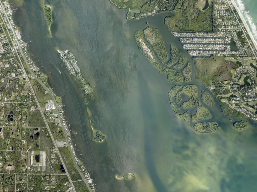
Where did all those low, palm-and-mangrove islands come from? And what is that neighborhood of pastel houses sitting out in the middle of the river with no bridge to it?
Both answers are better than you'd guess. One is a 1930s–1960s engineering project you can still camp on today. The other is a 50-acre island of 65 homes where there isn't a single car. Here's the full story of the water in our backyard.
Part 1: how the lagoon's islands were formed
Look closely and you're actually looking at two different kinds of land out there — one shaped by tides and mangroves over thousands of years, and one built by dredges within living memory.
The spoil islands: a byproduct of the Intracoastal Waterway
Most of the small islands strung along the Indian River Lagoon did not exist a century ago.
To create the Atlantic Intracoastal Waterway — the protected inland boat highway that runs down Florida's east coast — dredges cut and deepened a channel through the shallow lagoon. The material scooped off the bottom is called spoil. Today spoil is usually hauled to upland disposal sites, but for decades the practice was simply to pile it alongside the new channel as the dredge worked its way along. When a pile grew tall enough to break the surface, it stayed there. Wind and birds brought seed, mangroves took the edges, Australian pines and cabbage palms took the high ground, and a "natural-looking" island was born.
That's why so many of them share a family resemblance: long, narrow, running parallel to the channel, with a steep-ish edge on the channel side and a shallow sand shelf on the back side. Once you know the shape, you can pick out a spoil island from a natural one at a glance.
The islands are now managed by the Florida DEP's Indian River Lagoon Aquatic Preserves office through the Spoil Island Project, with volunteer help from Friends of the Spoil Islands (FOSI) — the group behind the island maps, adopt-an-island program, and cleanups.
Natural mangrove and tidal islets
Before the dredges, the lagoon still had islands. Currents moving through inlets like Sebastian Inlet dropped sand into bars; red mangroves colonized the bars, their prop roots trapped more drifting sediment and leaf litter, and over decades the bar became solid ground. These islands tend to be rounder, lower, more irregular, and almost entirely mangrove — no pines, no straight edges.
| Spoil island | Natural mangrove islet | |
|---|---|---|
| Origin | Dredge material from the ICW, mostly mid-20th century | Tidal sand deposits colonized by red mangroves |
| Shape | Long, narrow, parallel to the channel | Rounded, irregular, low |
| Vegetation | Mangrove fringe, Australian pine, cabbage palm, sea grape | Almost entirely mangrove |
| Elevation | Higher — often a dry sandy interior | Barely above high water |
| Landing | Allowed on islands designated Recreation | Usually no dry landing; often protected |
Not all islands are open — know the designation before you land
This is the part most visitors get wrong, and it matters. The Aquatic Preserve's Island Designation System sorts managed islands into categories, and each island is signed from the water:
- · Recreation — managed for public use. Day use, picnicking, swimming off the shelf, and primitive camping are allowed. Some have picnic tables, pedestal grills, and fire rings; many have nothing at all. Marked with a green tree symbol on the official maps.
- · Conservation — important nesting and foraging habitat. Do not land, do not walk around, keep pets off. Marked with a red "!" and blue signage on the island itself.
- · Critical Wildlife Area — two islands in the region (BC-49 and MC-2) are FWC-designated CWAs, closed to public access entirely, marked with in-water signs. Law enforcement writes citations past those signs.
If you plan to land or camp, pull up the Brevard County island layout map from the Spoil Island Project before you launch and pick a Recreation island by number.
Camping and day-use rules that actually get enforced
- · Camping is free, first-come first-served, on Recreation islands only. No reservations, no permits.
- · Use the designated sites. If every site on an island is taken, move to another island — don't create a new site.
- · No trash cans and no restrooms anywhere. Pack out all trash, and pack out human and pet waste too. Catholes are not an accepted alternative.
- · No fresh water on any island. Bring everything you'll drink; most ramps have no potable water either.
- · Campfires must stay inside existing fire rings (or, where there are none, kept small on bare ground). Cutting vegetation or collecting firewood is prohibited, and fires are banned outright during county or state fire bans.
- · Leave No Trace isn't a slogan out here — these islands sit inside an Aquatic Preserve and get heavy weekend use.
Part 2: the community in the middle of the water — VIP Island
Across the water from Christenson's Landing sits one of the most unusual neighborhoods on the Space Coast: VIP Island, also known historically as Grant Farm Island.
It's about 50 acres, part natural land and part spoil from the Intracoastal dredging, with roughly 65 homes — and it is one of the very few inhabited islands in Florida reachable only by boat.
From pineapples to "Vacation Island Paradise"
- · The farm era. The island's high, well-drained soil was farmed in the pioneer decades — pineapples and citrus — with the harvest boated across to the mainland at Grant, where the Florida East Coast Railway carried it north.
- · The subdivision. In the late 1950s the island was platted into residential lots and marketed as *Vacation Island Paradise* — VIP. Lots sold for about $1,995. The original plan included causeways to the mainland and the beach; they were never built, which is exactly why the island is what it is today.
- · Today. Small 0.15-acre lots now trade well north of $250,000, cottages run from the mid-hundreds up, and one large estate parcel at the far end listed at over $4 million.
Life without cars
There are no bridges, no paved roads, and no cars on VIP Island. "Main Street" is a meandering sand path traveled by golf carts, beach cruisers, and bare feet. Residents ferry everything by boat — groceries, lumber, refrigerators, and their own garbage. Weekdays are quiet with only a handful of full-timers; weekends fill up as the vacation-home owners come over. The mainland is roughly a five-minute boat ride away.
Please note: VIP Island is entirely private property. It's a wonderful thing to idle past and photograph from the water — it is not a place to land, tie up, or walk around. Admire it from the channel and give the docks a slow, no-wake pass.
Part 3: how to explore the islands from our dock
This is the best part about staying here — you don't need to trailer anything.
- · By kayak or paddleboard (included with your stay). Launch straight off our private dock. Go early, before the sea breeze fills in around 10–11am; the lagoon is glass at sunrise and a chore by afternoon. Stay off the ICW centerline and cross it quickly and perpendicular when you must.
- · By boat. Tie up at our dock for the week, or launch three minutes away at Christenson's Landing (or Long Point Park for a bigger rig). From there, the spoil island chain runs both north and south along the channel.
- · Watch your depth. Most islands are ringed by a shallow sand and seagrass shelf. Approach at idle, trim up, and land on bare sand — never drag a hull across seagrass.
- · Check the wind first, not just the forecast. Our Sebastian Inlet live cam page shows the lagoon side; a glassy river means a great paddling morning, whitecaps mean pick a different plan.
- · Bring shoes. Old shell and oyster hash on the shelf is unkind to bare feet.
- · Fishing. The channel edges and drop-offs around the spoil islands, plus the dock pilings along VIP Island, hold snook, redfish, spotted seatrout, and mangrove snapper. Our fishing guide covers licenses, bait shops, and where to start.
- · Wildlife. Manatees work the shallows and dolphins run the channel; ospreys and pelicans nest on the islands. Give nesting birds a wide berth, especially in spring and summer. See the manatees & wildlife guide.
Want a bigger day on the water? The Sebastian Inlet sandbar is 5.4 miles down the river from our dock, and On the Water has the full dock, ramp, and route details. No boat? Rentals and charters are within ten miles.
Experience the lagoon like a local
Whether you're paddling out to a spoil island at sunrise or watching the sun set behind VIP Island from our dock, staying at Sunrise on the River puts you in the middle of Old Florida's most interesting stretch of water.
Book direct and skip the platform fees →
Related reading: our dock, kayaks and the run to the inlet · kayaking & paddleboarding launches, fees and rentals · the Sebastian Inlet sandbar · manatees and wildlife
Boat and kayak launches near the house
Tap a launch to move the map. Drive times are from Sunrise on the River in Grant-Valkaria.
US-1 at Grant, Grant-Valkaria — Closest launch to the house. One concrete lane, boarding dock, straight into the lagoon with no bridges to Sebastian Inlet.
- Drive to Grant Boat Ramp at that hour: 4 min each way (15 min to unload and rig).
- On the water about 7:19 am, back home around 9:23 am.
- Total trip: 2.4 hours.
- Best departure for flat water and light traffic: 6:00 am — the lagoon is usually glass until about 10am.
| Launch | Drive | Fee | Route |
|---|---|---|---|
| 3 min · 1.2 mi | Free | Directions | |
| 5 min · 2.0 mi | Free | Directions | |
| 6 min · 2.0 mi | Free | Directions | |
| 18 min · 11 mi | Free | Directions | |
| 22 min · 14 mi | Free | Directions | |
| 22 min · 14 mi | $4–$5 per vehicle | Directions | |
| 20 min · 12 mi | $8 per vehicle | Directions | |
| 25 min · 17 mi | Free | Directions |
Three ways to stay and paddle
Kayaks are included with every stay at Sunrise on the River, launched from our own dock on the Indian River Lagoon — no rental counter, no trailer, no drive.
Sunrise Paddle Weekend
- · Kayaks included — launch straight off the private dock
- · Paddleboard-flat water from first light to about 10am
- · Fire pit and gazebo for the evening
Lagoon & Spoil Islands Week
- · Kayaks all week, no rental fees
- · Paddle the spoil islands and the Sebastian sandbar
- · Boat ramps under 2 miles for your own trailer
Snowbird Paddle Month
- · Kayaks, dock and screened porch for the whole stay
- · Manatee season on Turkey Creek and the St. Sebastian River
- · Two dogs welcome — $100 per dog per stay
Cleaning $150, dogs $100 each per stay, no resort fees. Check live availability.
Frequently asked
Can visitors land on the spoil islands in the Indian River Lagoon?
Only on islands designated Recreation. Those are open to the public for day use, picnicking, swimming, and primitive camping at no charge, first-come first-served. Islands designated Conservation are closed to landing because they are nesting and foraging habitat, and two islands in the region (BC-49 and MC-2) are Critical Wildlife Areas closed to all public access. Check the Spoil Island Project's Brevard County map before you go and read the signage on the island.
Do I need a permit or reservation to camp on a spoil island?
No. Camping on Recreation islands is free and first-come first-served with no reservations. Use the existing designated sites, keep fires inside the fire rings, and move to another island if every site is taken.
Are there restrooms or drinking water on the islands?
None. There is no fresh water, no restrooms, and no trash cans on any spoil island. You must bring all your water and pack out all trash plus human and pet waste. Many boat ramps have no potable water either, so fill up before you launch.
Can I drive a car to VIP Island?
No. There are no bridges to VIP Island (Grant Farm Island). Access is by private boat or kayak only, roughly a five-minute run from the mainland. On the island itself there are no cars at all — residents use golf carts, bicycles, and sand footpaths.
Can I visit or walk around VIP Island?
No. VIP Island is a private residential community of about 65 homes on 50 acres. Enjoy the view from the water at idle speed, but do not land, tie up at private docks, or walk the paths.
How were the Indian River Lagoon islands created?
Most were created as a byproduct of dredging the Atlantic Intracoastal Waterway. Material dug from the channel, called spoil, was piled alongside the cut, and when the piles broke the surface they became permanent islands that later vegetated with mangroves and pines. A smaller number are natural mangrove islets built up over thousands of years from tidal sand deposits.
Is the fishing good around the spoil islands?
It is excellent. The channel drop-offs beside the spoil islands and the residential dock pilings around VIP Island hold snook, redfish, spotted seatrout, and mangrove snapper. Early morning and the last hour of light are the most productive.
Can guests at Sunrise on the River paddle to the islands?
Yes. Kayaks and paddleboards are included with your stay and launch directly from our private dock, and Christenson's Landing boat ramp is three minutes away by car. Paddle at sunrise before the sea breeze builds, wear a PFD, and cross the Intracoastal channel quickly and perpendicular to the traffic.
The river, once a month
Fishing report, rocket launch dates, sandbar and manatee season, local events — plus the open dates we'd love to fill. One email a month, no spam.
One email a month. Unsubscribe any time — we never share your address.